Orangeville G & G2 Drive Test Routes
Practice real G & G2 driving test routes in Orangeville, ON

FREE APP DOWNLOAD ★★★★★


Practice real G & G2 driving test routes in Orangeville, ON
FREE APP DOWNLOAD ★★★★★
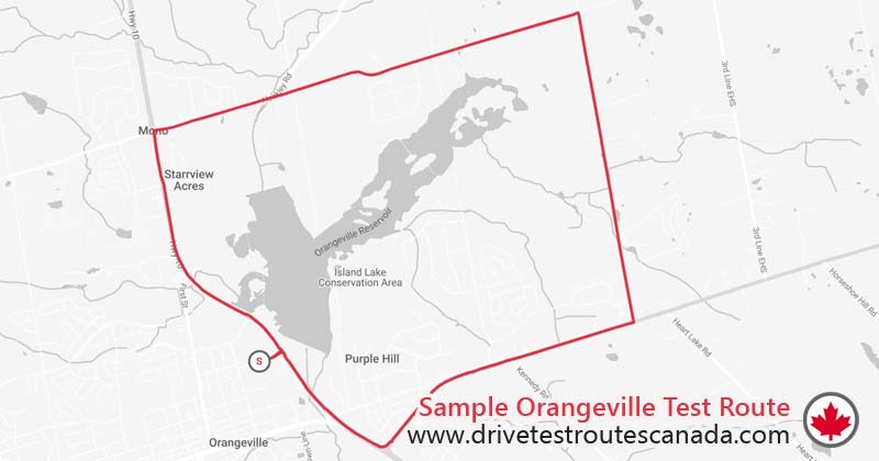
15.10 mins
Route Duration14.19 km
Route LengthOrangeville
Location| # | Instruction | Distance | Duration |
|---|---|---|---|
| 1 | Head east on 4th Ave toward ON-10 | 0.22 km | 1 min |
| 2 | Turn left onto ON-10 | 2.58 km | 3 mins |
| 3 | Turn right onto Hockley Rd/ | 1.15 km | 1 min |
| 4 | Continue straight onto Side Rd 5 | 0.28 km | 1 min |
| 5 | Head east on Side Rd 5 toward 1st Line EHS | 2.71 km | 2 mins |
| 6 | Turn right onto 2 Line EHS Mono | 2.95 km | 3 mins |
| 7 | Turn right onto ON-9 W | 0.96 km | 1 min |
| 8 | Head west on ON-9 W toward Kennedy Rd N | 0.71 km | 1 min |
| 9 | Head west on ON-9 W | 0.94 km | 1 min |
| 10 | Turn right onto ON-10 (signs for Orangeville/ | 1.03 km | 1 min |
| 11 | Head northwest on ON-10 | 0.14 km | 1 min |
| 12 | Head northwest on ON-10 toward Vicki Barron Lakeside Trail | 0.27 km | 1 min |
| 13 | Turn left onto 4th Ave | 0.25 km | 1 min |
Disclaimer: This sample route is for demonstration purposes only and does not represent the actual test routes used during the test. Accurate Orangeville driver test routes are available on our app.
Note: Hours may vary on holidays.
Public: G2 | G | M2 | LM2
Commercial: A | B | C | D | E | F | Z
G Test: 63%
G2 Test: 63%