Manitouwadge G & G2 Drive Test Routes
Practice real G & G2 driving test routes in Manitouwadge, ON

FREE APP DOWNLOAD ★★★★★


Practice real G & G2 driving test routes in Manitouwadge, ON
FREE APP DOWNLOAD ★★★★★
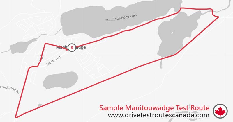
14.13 mins
Route Duration11.28 km
Route LengthManitouwadge
Location| # | Instruction | Distance | Duration |
|---|---|---|---|
| 1 | Head east on Manitou Rd toward Huron Walk | 0.63 km | 1 min |
| 2 | Head east on Manitou Rd toward Lynx Ave | 0.90 km | 1 min |
| 3 | Head east on Manitou Rd | 1.11 km | 1 min |
| 4 | Turn right | 0.96 km | 1 min |
| 5 | Sharp right | 1.10 km | 1 min |
| 6 | Head southwest toward Station Rd | 3.57 km | 3 mins |
| 7 | Head west toward ON-614 N | 0.47 km | 1 min |
| 8 | Turn right onto ON-614 N | 1.34 km | 2 mins |
| 9 | Turn left onto Adjala Ave | 0.56 km | 1 min |
| 10 | Turn right onto Ohsweken Rd | 0.12 km | 1 min |
| 11 | Head east on Ohsweken Rd toward Micmac St | 0.36 km | 1 min |
| 12 | At the roundabout, take the 2nd exit onto Manitou Rd | 0.18 km | 1 min |
Disclaimer: This sample route is for demonstration purposes only and does not represent the actual test routes used during the test. Accurate Manitouwadge driver test routes are available on our app.
Manitouwadge DriveTest
Manitouwadge Recreational Centre
2 Manitou Rd
Manitouwadge
ON P0T 2C0
Phone: 1-800-489-8450
Note: The Manitouwadge DriveTest Centre operates as a travel point and is open only on specific dates.
Public: G2 | M2 | LM2
Commercial: A | B | C | D | E | F | Z